
June 3, 2014 — The U.S. Geological Survey appears to subscribe to the old adage that a picture is worth a thousand words — and to the power of citizen science. We previously reported on the organization’s effort to create long-range surveys of native bee populations that relies on specimens sent in by citizen scientists, biologists and others. Now the USGS is tapping the public again with “iCoast – Did the Coast Change?”
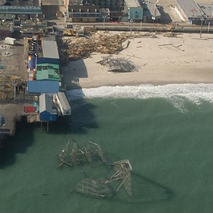
After hurricanes and other storms along the Atlantic and Gulf coasts, the USGS takes aerial photos and compares them to pre-storm images. The practice, which has taken place since 1995, has led to nearly 150,000 photos — too many for the USGS to analyze on its own. So the organization launched iCoast, which crowdsources identification of changes to coastal lands after extreme storms by inviting everyday people to tag affected areas for issues such as beach and dune erosion, overwash, and dead vegetation. The tool isn’t just meant to tell the story of what’s happened as a result of these storms; the USGS sees it as a way to better predict coastal erosion, which will help residents and community managers understand where coasts might be most vulnerable.
“Computers cannot yet automatically identify damages and geomorphic changes to the coast from the oblique aerial photographs,” said Sophia B. Liu, a fellow in the USGS’s Mendenhall Postdoctoral Research Fellowship Program, in a statement. “Human intelligence is still needed to finish the job.” Photo from the U.S. Geological Survey
Ensia shares solutions-focused stories free of charge through our online magazine and partner media. That means audiences around the world have ready access to stories that can — and do — help them shape a better future. If you value our work, please show your support today.
Yes, I'll support Ensia!