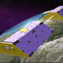

August 28, 2013 — For years, says University of California, Irvine, hydrologist Jay Famiglietti, remote sensing of groundwater was regarded in the hydrologic community as “a Holy Grail.” Famiglietti oversees the analysis of priceless data gathered by a pair of NASA satellites. Known as GRACE — for Gravity Recovery and Climate Experiment — the satellites measure groundwater at various locations beneath Earth’s surface, amazingly, by observing each other, their distance apart and their relative speed. Michael Watkins, a Jet Propulsion Laboratory researcher who helped design the mission with colleagues in Texas and Germany, says GRACE “puts a bathroom scale under the distribution of water on Earth.” The two satellites fly in a low polar orbit 311 miles above the Earth and about 140 miles apart, one behind the other. Because a greater mass exerts a stronger gravitational pull, the lead satellite speeds up ever so slightly when orbiting over a larger mass, such as Mount Everest, and pulls ahead of its follower in space. That slight separation can be measured “unbelievably precisely,” says Watkins, down to the nanometer level. As the satellites circle the Earth they compile a record of gravitational change. This turns out to be mostly a record of the mass of water, because water is constantly changing, whereas rock stays in place. When launched in 2002, GRACE cost NASA $90 million, a low price in an era when research satellites can easily cost a half-billion dollars. A successor, GRACE-FO, is expected to launch in 2017. Article by Kit Stolz; photo courtesy of earthobservatory.nasa.gov
Ensia shares solutions-focused stories free of charge through our online magazine and partner media. That means audiences around the world have ready access to stories that can — and do — help them shape a better future. If you value our work, please show your support today.
Yes, I'll support Ensia!