
January 26, 2024 — In the Benediction for his 1968 autobiographical book, Desert Solitaire: A Season in the Wilderness, American author, essayist and environmental advocate Edward Abbey wrote, “May your rivers flow without end, meandering through pastoral valleys.” Today, many of those pastoral valleys have become homes to dams — altering the flow of rivers, sometimes ending it prematurely, and creating issues downstream we have only begun to understand.
In June 2022, Evan Dethier, then a postdoctoral fellow at Dartmouth, led a study using satellite images from the NASA/USGS Landsat Program and digital hydrologic data records from 1984 to 2020 that found that dam building in the 20th century had caused the rivers of North America, Europe/Eurasia and Asia to deliver 49% less suspended sediment to the oceans.
“Humans have been able to alter the world’s biggest rivers at rates that are unprecedented in the recent geological record,” Dethier said in a release of the study’s findings.
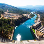
In 2019, hydropower, including that generated by dams, accounted for an estimated 60% of all renewable electricity. Dams are important for preventing floods, and they provide water for domestic and industrial use; it has been estimated that as much as 40% of irrigated land globally relies on dams. The Hoover Dam generates electricity for 1.3 million people in California, Nevada and Arizona; provides water for 16 million people; and irrigates more than 1.5 million acres (600,000 hectares) of land.
But, says Dethier, those benefits come with downsides.
“Dams alter the seasonal passage of water,” he says. “They also block the passage of fish and other important organisms. And, as we continue to learn, they trap vast amounts of sediment.”
To understand why that’s important, we need to take a closer look at sediment.
Biodiversity Bed
A 2011 estimate put the amount of sediment trapped behind the world’s dams at 73 cubic kilometers (18 cubic miles) — more than two times the maximum storage capacity of Lake Mead, the reservoir formed by the Hoover Dam and the largest reservoir by volume in the U.S. It’s estimated that by the middle of this century, dams worldwide will lose about 26% of their water storage capacity due to sediment buildup.
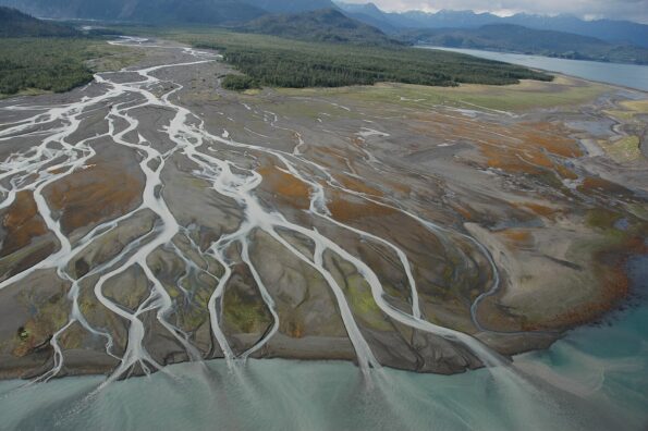
“The flow of the river and the sediment it carries creates the form of the river and how it will migrate over hundreds to thousands of years,” says Jim Best, professor of sedimentary geology at the University of Illinois Urbana-Champaign. Photo of the Lower Cook Inlet of Alaska’s Kachemak Bay by National Oceanic and Atmospheric Administration (NOAA), public domain
Sediment comes in different sizes. Coarse sediment forms the “architecture” of most riverbeds, while fine-grained sediment is important for some floodplains and mudflats, as well as for conveying nutrients. “In general, we tend to trap coarser sediment and flush finer sediment downstream, and not replacing the coarser sediment can lead to the changing of the downstream environment, which can sometimes exacerbate the risk of flooding,” says Jim Best, professor of sedimentary geology at the University of Illinois Urbana-Champaign.
“The flow of the river and the sediment it carries creates the form of the river and how it will migrate over hundreds to thousands of years,” he says. “Rivers also provide ecological niches for a wide range of creatures, and the deposition of sediment and its sculpting creates those habitats. And the nutrients and organic materials it carries creates biodiversity in many of the world’s rivers.”
According to Brian Cluer, staff geomorphologist and research physical scientist for the West Coast Region of NOAA National Marine Fisheries Service, “many areas have been damaged or destroyed due to a lack of sediment. Now, one price we’re paying for that is endangered or valuable species damaged because of being denied habitat necessary for their life cycle. Salmon spawning beds are being damaged or destroyed, and processes that recharge floodplains are disrupted as some of the best farmlands are not being replenished with fresh sediment. Downstream, estuaries deprived of sediment are becoming more vulnerable to rising global sea levels.”
Dam Removal
Cluer was involved in the 2011 project to remove the Elwha Dam in Olympic National Park as part of the Elwha River Ecosystem and Fisheries Restoration Act, at the time the biggest dam removal in the U.S.
“The aftermath of the Elwha Dam removal shows the positive things that can happen when sediment is allowed to reach the mouth of the river. The beach area, once composed of volleyball-sized rocks, is now sandy and extends for hundreds of meters offshore. Clam fishing has returned, as well as salmon, and the extended shoreline provides protection from storms and sea level rise,” Cluer says. “When sediment is deposited, it creates the ability of the river to meander again, improving the richness and diversity of habitats.”
Meanwhile, Dethier says, the removal of dams along the Klamath River, which runs through Oregon and Northern California, “is an exciting test case for what happens to a river when four long-standing dams are removed. It will be interesting to follow the river’s recovery. Research tells us that if dams are removed properly, rivers can be incredibly resilient.”
Removing dams properly is key. While returning sediment downstream “is, in the long run, positive for the ecosystem, as it replenishes what was lost during the life of the dam and improves connectivity to floodplains, which we know is vital to river health,” Cluer says, he warns that this solution is “a large disturbance event, and there are impacts to existing habitats.” When assessing the impacts of dam removal, Cluer continues, much of the work involves predicting the short-term negative impacts and comparing them to predicted long-term benefits.
For example, Cluer says, “if the dam has stored sediments from an industrial area, the sediment could contain pollutants, and if it is contaminated, you get a polluted wave of sediment headed downstream, causing an impact on the river environment.”
One such example is highlighted in a study on the Mud River Reservoir in West Virginia, downstream from the mountaintop Hobet coal mine, which operated from 1974 to 2015. In the study, sediment cores showed increases in the storage of inorganic carbon, selenium and calcium, “which could have lasting impacts on reservoir biota and downstream environments long after reclamation efforts are applied.”
Other Solutions
In lieu of releasing sediment during dam removal, there are other ways to remove sediment buildup behind dams. For example, “dredging is most likely to be least impactful to downstream environments because flushing has much more negative consequences, such as increased turbidity, increased nutrient loading, higher heavy metal contamination and the like,” says Aubrey Hillman, an assistant professor in the Department of Atmospheric and Environmental Sciences at the University at Albany. However, getting the dredged sediment to areas where it’s needed can be expensive, especially if the dam is in a remote area, Cluer warns.
Other approaches include ways to bypass dams and feed water, fish and sediment back into rivers, such as a connecting channel around a reservoir as part of the Chimney Hollow Reservoir project in Colorado. Meanwhile, in Japan, a 4.3-kilometer (2.7-mile) bypass tunnel on the Miwa Dam completed in 2004 moves an average of 399,000 cubic meters (522,000 cubic yards) per year of mostly fine sediment, while coarse sediment is trapped upstream for use in construction.
Rivers at Risk
Two of the world’s longest and most famous rivers, and the ecosystems and people that rely on them, are facing risks of river sediment not reaching deltas due to existing or proposed dams.
According to Al Jazeera, the Nile River discharged more than 120 million metric tons (132 million tons) of sediment annually to its delta before the Aswan Dam was constructed in the 1960s. In recent years, sediment reaching the delta, which supports half of Egypt’s economy and is home to more than 40% of its people, has dropped 98%, and estimates indicate that thousands of acres of the delta could be under water by century’s end due to a combination of the missing sediment and rising sea levels. Water quality issues have increased as well due to the disruption of the river’s natural flow, which historically flushed salts and contaminants from the delta.
Additionally, the dam has helped lead to an increase in schistosomiasis, a disease caused by parasitic worms spread by freshwater snails that infects hundreds of millions of people worldwide and kills some 200,000 each year.
“Society chose years ago to maximize short-term agriculture by disconnecting our rich floodplains from their river sediment sources,” Cluer says. “Levees, dams, channelization, more people, more food, but no understanding of the massive looming problems due to the loss of floodplain-forming processes. Without reconnecting floodplain farmlands to the river and its sediment supply, the land and its soil are not long-term sustainable.”
Additionally, Cluer points to negative effects on aquifers around the world. “If you disconnect rivers from the floodplain, you deplete the underlying water supply. Disconnected floodplains then have to be irrigated, and when irrigation water comes from groundwater aquifers, we risk overdrafting them, and aquifer compaction results. And a compacted aquifer in the basin cannot be recovered,” he says. “The compaction of global aquifer basins is irreversible.”
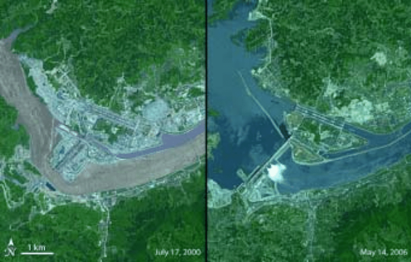
In this pair of images showing the Three Gorges Dam on the Yangtze River in central China in partial completion in July 2000 (left) and in May 2006, sediment-filled water can be seen flowing through a channel in the earlier photo, but not by the time the dam spanned the entire river in 2006, when a large reservoir was formed behind it. Photo created by Jesse Allen, Earth Observatory, using ASTER data made available by NASA/GSFC/MITI/ERSDAC/JAROS, and U.S./Japan ASTER Science Team
On the other side of the world, the Amazon River Basin is roughly 7 million square kilometers (nearly 3 million square miles) — covering about 40% of South America — and within its reaches, more than 300 dams are proposed that will impact the region and beyond.
“These proposed projects threaten one of the world’s greatest remaining resources, with biological, human and aesthetic consequences to this region,” University of Illinois Urbana-Champaign’s Best says. “Where we build a dam, we change the area’s balance.”
In 2021, researchers including Suyog Chaudhari of the Michigan State University Department of Civil and Environmental Engineering published a study looking at the use of in-stream turbines in the Brazilian Amazon as an alternative to planned storage-based hydropower projects. The study estimated that “~63% of the total energy planned to be generated from conventional hydropower in the Brazilian Amazon could be harnessed using in-stream turbines that use kinetic energy of water without requiring storage.”

Given the large number of dams planned or proposed for the Amazon, what could be the impact on the second-longest river in the world?
“When you disconnect the river from its floodplains, you impact carbon sequestration, you impact aquifer recharge, and you impact a vast natural ecosystem,” says Cluer.
Not Just Rivers
Other bodies of water are similarly affected. Hillman, whose focus has been on lakes across the country and overseas, says in her work she’s found that “sedimentation rates have skyrocketed in the 20th century, and a big impact has been the number of dams that are on rivers feeding into lakes.” When they do dredging or sluicing, she says, sedimentation rates shoot up fast.
“Each lake is unique, and we walk a fine line between too much sediment and too little. Sediment is critical to keep a lake thriving, delivering things like nitrogen and phosphorus. We did a study in New York that found that more than 50% of phosphorus that comes into a lake comes through sediment.” But, as the saying goes, too much of a good thing can be bad — in this case, too much sediment can help create a now-familiar scene of a lake covered in blue-green algae, or cyanobacteria. These algae blooms impact human recreation, kill aquatic species and more. “Much more research is needed on the interaction between rivers, lakes and dams,” Hillman says.
The San Francisco Bay is home to hundreds of acres of baylands that support fish and wildlife, protect the shoreline and help buffer the impact of sea-level rise. Scott Dusterhoff, program managing director and senior scientist for the Resilient Landscapes Program at the San Francisco Estuary Institute, says the focus in an institute report called “Sediment for Survival” was to look at the impacts of lost sediment on marshes and tidal areas, a problem he describes as growing over time.
“In San Francisco Bay, the habitat provided by the marshes is super important,” says Jessica Lacy, research oceanographer with the USGS Pacific Coastal and Marine Science Center. “The marshes are also located in places where they’re protecting coastal communities.”
“We get a lot of sediment from the delta, which is fed by the San Joaquin and Sacramento rivers,” Dusterhoff says. He explains that sediment brought to the bay during the 1800s gold rush, through hydraulic mining, blowing up mountains and other approaches, moved the shoreline out into the bay, creating close to 200,000 acres (81,000 hectares) of tidal marsh. But, according to the report, “diking of baylands in the 19th and 20th centuries for agriculture, development, and commercial salt production resulted in an approximate 65% reduction in bayland extent compared to the early 19th century.” Dusterhoff goes on to explain that “more recently, the sediment supply to the bay from the delta has been decreasing, due, in large part, to all that gold mining working its way through the system and the building of large dams in the Sierra Nevada.”
With approximately 40% of the world’s population living within 100 kilometers (62 miles) of a coastline, what is happening to the San Francisco Bay area is an important example to pay attention to.
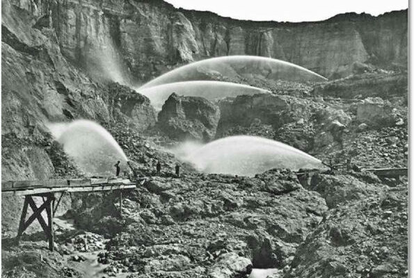
Hydraulic mining activity in the foothills of the Sierra Nevada, used in the 1800s to search for gold, brought sediment to the coast, moving the shoreline out into the bay. Photo public domain, USGS
According to Sediment for Survival, more than 450 million cubic yards (344 million cubic meters) of sediment will be needed by 2100 to maintain the bay’s current wetlands and mudflats, as well as areas planned for restoration. “The amount of sediment coming in now isn’t close to what’s needed to allow the shoreline to survive where it is,” Dusterhoff says. “It’s likely we won’t be able to save every tidal marsh, so there will be some tough choices to make.”
Learning to Do Better
In the face of such difficult decisions, humans should “take advantage of natural capital,” says Best. “Rivers provide floodplains for agriculture, environments for fish. They help provide energy, recreation and more, and we’ve been thriving in those areas for thousands of years. Now we’re changing natural capital in ways that are just not sustainable.”
Cluer agrees. “Making ecosystems smaller and less resilient by disconnecting floodplains from rivers is a diminishing curve that citizens don’t realize is a big problem,” he says. “It takes a better government than we have today to address this problem. We don’t seem to have the ability needed for long-term planning.”
“This is an exciting time, as we learn more and more about free-flowing rivers and the good they do for communities and for the environment.” –Evan Dethier
Along those lines, Best says, “transnational agreements are critical. Large rivers are often transboundary rivers, so we can’t do anything without a proper governmental and management structure.” He points to the Danube and Rhine rivers, which together cross 14 countries. “In the last 20 years, there’s been much better agreement between those nations about protecting the rivers and their environment.”
While Best sees promise in the future health of rivers where dams are being decommissioned and through technologies such as NASA’s Surface Water and Ocean Topography (SWOT) mission that allow for better remote monitoring of river flows, he says that dams and reservoirs being built or planned in the Global South are “where the new pressures are the most extreme.” He cautions: “We need to learn from the things we haven’t done well in the last 50 years.”
Dethier, now an assistant professor at Occidental College in Los Angeles, emphasizes Best’s point, saying, the next decade will be critical, “and not just in rich nations. All environmental challenges are interconnected. We can, and we must, do a better job of taking care of the environment.” He continues on an optimistic note: “This is an exciting time, as we learn more and more about free-flowing rivers and the good they do for communities and for the environment.”
In Desert Solitaire, Edward Abbey later describes what one might see if such free-flowing rivers went on without an end, through pastoral valleys: “something strange and more beautiful and more full of wonder than your deepest dreams waits for you — beyond that next turning of the canyon walls.”
Related Posts

Ensia shares solutions-focused stories free of charge through our online magazine and partner media. That means audiences around the world have ready access to stories that can — and do — help them shape a better future. If you value our work, please show your support today.
Yes, I'll support Ensia!