
August 19, 2013 — Stretching from the white limestone mountains of southern Turkey through the floodplains of the Tigris and Euphrates rivers into what is now northern Syria, Iraq and Iran, ancient Mesopotamia gave rise to some of the earliest irrigated agriculture, and then to the first cities in the world.
Now, 8,000 years after prehistoric farmers dug canals to water arid crops here, NASA satellites tracking global changes to freshwater resources reveal the same region that helped birth agricultural civilization is signaling one of the strongest warnings of its mortality.
Analyzing data from twin satellites that detect water mass by measuring changes in Earth’s gravity, scientists say the Middle East lost 117 million acre-feet of freshwater between 2003 and 2009 — nearly enough to fill the Dead Sea. The researchers attributed about one-fifth of the loss to dwindling snowpack and drying soils, the result of drought. Surface water decreases from lakes and reservoirs made up another fifth. But groundwater pulled the biggest vanishing act. Sixty percent of the loss was pumped up and out of the region’s fragile aquifers, with irrigation the primary drain.
“We’ve never been able to see, this clearly, the widespread nature of groundwater depletion,” says Jay Famiglietti, director of the University of California’s Center for Hydrologic Modeling at UC Irvine and lead investigator on NASA’s Gravity Recovery and Climate Experiment groundwater studies. Now in its 12th year of orbit, GRACE offers an unprecedented view of global aquifer storage and the movement of groundwater — least understood of all freshwater, and source of nearly half the irrigation and drinking water in the world.
Northwest India is another region losing a troubling quantity of the water stored underground. In 2009, Famiglietti’s team found that in just six years, the states of Rajasthan, Punjab and Haryana — the nation’s wheat belt and home to 114 million people — had lost 88 million acre-feet of groundwater, twice the capacity of India’s largest surface-water reservoir.
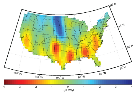
GRACE data paint a striking portrait of regions in which U.S. freshwater reserves (largely groundwater) have increased (blue) or decreased (red) since 2003. Areas of concern include California’s Central Valley, the southern High Plains Aquifer, drought-stricken areas in the South, and the Upper Missouri River Basin region. Image courtesy of Jay Famiglietti and Caroline de Linage, UC Irvine.
GRACE data also reveal shrinking aquifers beneath the North China Plain, North Africa, southern Europe and a quintuplet of hot zones in the United States. In a new analysis of total U.S. freshwater storage — all the surface water, snow, soil moisture and groundwater in the land — GRACE reveals five areas where groundwater pumping far outstrips the ability of aquifers to recharge. Some are well known: California’s Central Valley, the southern High Plains Aquifer and Houston. Others, tucked into some of the nation’s wettest corners, come as a surprise: a wide swath of Virginia and the Carolinas, and almost all of Alabama — home to Mobile, the rainiest major city in the continental U.S. While the groundwater losses in other parts of the world are spread across much larger regions, Famiglietti warns that America’s hot spots “are right up there with the Middle East and India in terms of the rates of depletion.”
Exploited Aquifers
Trying to comprehend Earth’s groundwater is like trying to fathom all the information on the Internet. And like the Internet, groundwater gives rise to a considerable amount of misinformation — from books that leave readers thinking of aquifers as “underground rivers” to the EPA’s public Twitter feed, which not long ago repeated the common myth that the Great Lakes hold one-fifth of all the world’s freshwater reserves.
Surface waters are just the hyperlinks — mostly connected, but not always — to vast and layered stores of freshwater below ground.In reality, groundwater does not flow so much as seep through porous rock, clay or sand aquifers, built up over millions of years under most of Earth’s land. And while it’s true that the Great Lakes hold one-fifth of the world’s fresh, unfrozen surface water, all the freshwater we see — rivers, streams, lakes and wetlands — is a tiny fraction of all freshwater, less than 1 percent. Surface waters are just the hyperlinks — mostly connected, but not always — to vast and layered stores of freshwater below ground.
Throughout human history, this largely invisible water acquired a great mysticism as it bubbled up in wells and springs, sometimes deep and other times shallow, sometimes icy and other times hot. Its witching nature remains so enduring that the United States has a vigorous Society of Dowsers, and children still toss pennies into fountains to make a wish.
In a famous ruling in 1861, the Ohio Supreme Court codified the mystery when it declared the movement of water underground “so secret, occult and concealed” that it would be “practically impossible” to regulate. The case led to widespread adoption of the English common law rule of “absolute ownership” for groundwater in the United States, still practiced in some parts of the nation, such as Texas with its law of the biggest pump: Landowners could pump as much as they wanted from their own property, regardless of harm to neighboring wells and ecosystems.
While states including Texas and nations have made some attempts to manage groundwater in the 150 years since, the biggest pump represents the cardinal problem for groundwater in the U.S. and around the world. Aquifers may be mysterious, but they’re not magic. Despite their vastness, they cannot maintain water if the rate of pumping exceeds that of recharge.
The most-exploited aquifers in the world are those in major agricultural regions that are slow to recharge. These include the Central Valley and High Plains in the United States, the Nile Delta of Egypt, and the Upper Ganges of India and Pakistan. A stress index published in 2012 in the journal Nature found that 20 percent of the world’s aquifers are being overpumped, some massively so. The researchers, from McGill University in Montreal and Utrecht University in the Netherlands, found the Upper Ganges is being pumped more than 50 times its ability to recharge.
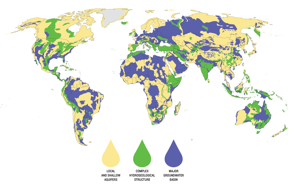
Just as the distribution of lakes and rivers varies around the world, so too does the distribution of aquifers. Major basins (purple) hold abundant, relatively easily extracted groundwater. More complex basins (green) might contain multiple aquifers separated by impermeable rock or have layers of saltwater as well as fresh. Local and shallow aquifers provide only limited quantities of water. Map created by Peder Engstrom and Kate Brauman of the Institute on the Environment’s Global Landscape Initiative. Data provided by BGR & UNESCO (2008): Groundwater Resources of the World 1 : 25 000 000. Hannover, Paris.
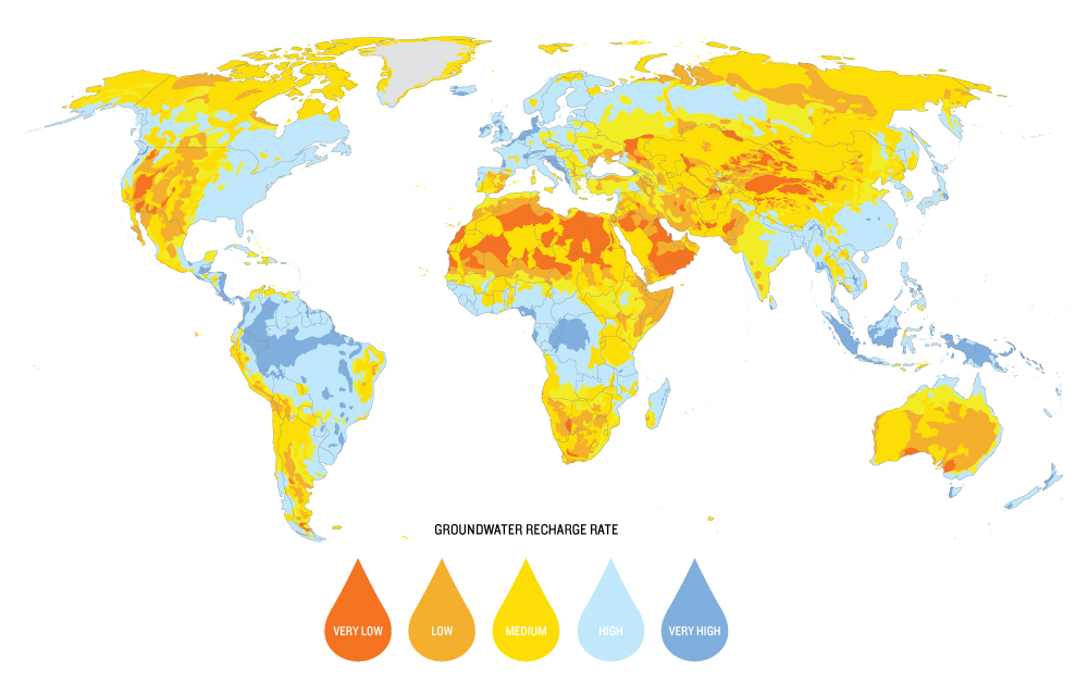
The rate at which rain, snow and surface waters are able to replenish groundwater varies tremendously from one place to another, mostly due to geology and climate. Along with aquifer size and type, the recharge rate determines the extent to which groundwater can be sustainably withdrawn for human use. Map created by Peder Engstrom and Kate Brauman of the Institute on the Environment’s Global Landscape Initiative. Data provided by BGR & UNESCO (2008): Groundwater Resources of the World 1 : 25 000 000. Hannover, Paris.
Scientists fear climate change and associated drought will worsen the picture. “With surface water disappearing because of climate change, groundwater increasingly becomes the water of necessity,” says Oregon State University professor Michael Campana, a hydrogeologist who has studied groundwater management for four decades. “It’s a problem for aquifers, and a potential conflict for people.”
Using Less, Banking More
The solutions to overdrawn aquifers are similar to those for overdrawn bank accounts. Foremost is reining in overconsumption. Cities and farmers alike have shown that we can live with less water. Facing severe groundwater depletion in the 1980s, residents of Tucson, Ariz., have managed to reduce their daily Big Gulp from 200 gallons per person in 1985 to 130 gallons today. At the same time, the city has transitioned away from mining the aquifer as its primary source. Three-fourths of Tucson’s water supply in 2003, groundwater now accounts for less than half — with the remainder drawn from the Colorado River and reclaimed sewer and industrial sources.
From the coastal plains of India to the High Plains of Kansas, meanwhile, some farmers are proving the power of local solutions. In Andhra Pradesh on India’s southeastern coast, a project to put groundwater data and management into the hands of local farmers has led to reduced use — through diversified crops and water-saving irrigation — with no reduction to profit. Following a package of water management bills that passed the Kansas Legislature last year, irrigators in a section of the Northwest Kansas Groundwater Management District have approved a self-imposed 20 percent reduction in pumping from their shrinking aquifer in exchange for more flexibility in the way they use their water rights.
Replenishing aquifers is another potential solution. This summer, Georgia is testing a technological peace offering known as ASR — Aquifer Storage and Recovery — in its 20-year water war with Florida and Alabama. The idea is to drill a well into the Floridan Aquifer that underlies the region and draw water from it in rainy times, storing the extra water deeper underground. In dry seasons when farmers fire up their pumps and the region’s streams and rivers begin to choke, the reserved water would be drawn back up into the Floridan Aquifer to help increase the flow.
The idea of replenishing aquifers “is going to be vitally important here and around the globe” as aquifers continue to decline and as massive reservoirs fall out of favor due to costs and evaporative losses.Georgia officials hope their demonstration will prove the potential of a water-sharing plan. But environmentalists worry the region hasn’t done nearly enough to reduce water demand. And ASR isn’t always an option. While an estimated 1,900 ASR wells operate in the U.S., some aquifers are too prone to contamination for the technology to be used.
David Pyne of ASR Systems, who is designing the Georgia project, says the idea of replenishing aquifers “is going to be vitally important here and around the globe” as aquifers continue to decline and as massive reservoirs fall out of favor due to costs and evaporative losses. Saudi Arabia is using aquifer storage to bank desalinated water during periods of low use and pump it back up when demand is high. Orange County, Calif., has a different twist. Its Groundwater Replenishment System purifies wastewater that used to dump into the Pacific Ocean, shoots it down into the aquifer, then uses it over and over again. The cycle requires far less energy than importing water from northern California or desalinating water from the sea.
Of course, any technology is only as good as the people and institutions managing the water. Aquifers storing injected water can be overtapped as readily as those holding native groundwater. Places such as California with scant statewide groundwater regulation can see the resource well managed in Orange County and exploited in the Central Valley, where overpumping continues to deplete aquifers, sink land and degrade water quality.
Tough Decisions
Ultimately, solutions hinge more on leadership and ethics than pipes and pumps — and willingness to make tough decisions on behalf of the future. In some areas, for example, “we should consider retiring groundwater pumping,” Campana says. “It’s time to ask ourselves: Is it worth it to mortgage our future water supply to grow alfalfa?”
In Texas, economic incentives have helped convert irrigated cotton crops to native grasslands — in some cases funded by third-party businesses as a mitigation credit. When it comes to food, agricultural researchers predict dryland farming will become crucial to meeting the production demands of a growing world.
Geopolitical cooperation is the next act on an international stage that has featured shared Water has more often been a source of international cooperation than of war.rivers, but paid less attention to shared aquifers such as the Upper Ganges, which irrigates crops in both India and Pakistan. Argentina, Brazil, Paraguay and Uruguay have taken the unusual step of signing a transboundary agreement on the Guarani Aquifer before any conflicts have arisen; the plan is the first under the United Nations’ new Law of Transboundary Aquifers.
The real test is whether people already in conflict can come to share and restore aquifers. Contrary to conventional wisdom, the Pacific Institute, which has tracked water conflict throughout human history, found that water has more often been a source of international cooperation than of war.
Crunching his satellite data, UC Irvine’s Famiglietti hopes the clear new science on aquifers once considered “secret, occult and concealed” will help lead to sustainable groundwater management as depletion becomes impossible to deny.
“We can now see the aquifer being depleted, the river basin running out of water, even unauthorized releases,” he says. A range of answers — technological, civil, policy and legal — are all “very much within grasp with vision and leadership. Inaction is not an option.”
![]()
Ensia shares solutions-focused stories free of charge through our online magazine and partner media. That means audiences around the world have ready access to stories that can — and do — help them shape a better future. If you value our work, please show your support today.
Yes, I'll support Ensia!
I of course agree that there are over exploited aquifers, and the discussion over interventions to better manage groundwater resources is very valid, I just motivate for a different method by which this groundwater stress is determined. Stress indices based on a simple abstraction/ recharge proportion are over simplified and cannot inform the management of that aquifer.
water abstraction ( removal) is environmentally acceptable, I think it
would be important to work with ecologists
to determine what impacts the abstraction
has on the ecosystems in the catchment
and watershed area. Providing water for
sustainable human uses is important, but so
is providing water to support the ecosystems. that. support us . We no longer
have pristine ecosystems-- we have socio-ecological systems-- all known ecosystems have been affected by human activities.
.
Even our standards of what we call pristine
ecosystems have been affected by shifting
baselines-- we cannot recognize pristine
ecosystems because there are none left and we in our times have never seen them.
Of course we know that not only humans are dependent on groundwater resources.
Some rivers in the US have become intermittent, and this is not only due to local or widespread droughts, but to widespread over pumping. In 2014, due to a drought but also to extreme over pumping and overuse of water in an arid ecosystem,
California is considering trucking salmon to their destinations, since both young salmon and mature salmon are migratory-- the young migrate from freshwater to the ocean,,and the mature salmon migrate back
from the ocean to their natal rivers to breed.
It is vital to learn to use precious freshwater
supplies sustainably, but equally vital to consider whether or not it is wise to suggest that humans should continue to try to live in arid and semi-arid areas, which climate change is expected to worsen and to make
much hotter in many places, when humans depend on freshwater supplies for agriculture ( in California 80% of freshwater supplies go to agriculture,
which is often not used sustainably), as well
as for drinking, or for pastoralism in some
less-developed countries.
It is important to consider what we are doing with water and with our natural
ecosystems,since we are entering what appears to be the Sixth Mass Extinction.
Adapting to and mitigating climate change
if possible is important for humans,but it is
equally important to consider the impacts
on biodiversity , and water is a main limiting factor, not just for humans, but for
species and ecosystems-- some of which many depend on connections to underground aquifers.
While desalination may appear an attractive if energy expensive alternative
on sea coasts, desalination must affect the
ocean ecosystem where it occurs -- and it
would normally occur on coasts and continental shelves,which, due to their
nutrient-rich location, are sea life and fish
nurseries. Can desalination occur without
affecting plankton? An enormous amount
of. sea life starts as plankton and depends on phytoplankton. Would not this cycle
be perturbed or even irreversibly harmed
by desalination? Should not the biological
effects of desalination be investigated before we commit harms,rather than first
investing enormous amounts of. money,and then discovering the ecological damage?
Would desalination be discontinued if it turned out to cause further irreversible harm to the ocean ecology, or would we simply continue,having invested?
Water is important for the ecosystems on which we are dependent, not just for us .
It is really important to look at the big picture, rather than jut the human-focused
picture, before we do irreversible harm to
the ecosystems without which we cannot survive.
Trigger issues / plan /implement /monitor and report/review and evaluate/ then plan again.
As an agronomist I thought your work excellent and wonder what you might think today! My own book should be out in the next month and is titled Earth, a Planet in Peril, and is all about reducing our footprint.