April 26, 2016 — When you think of artificial intelligence, the first image that likely comes to mind is one of sentient robots that walk, talk and emote like humans. But there’s a different kind of AI that’s becoming prevalent in nearly all of the sciences. It’s known as machine learning, and it revolves around enlisting computers in the task of sorting through the massive amounts of data that modern technology has allowed us to generate (a.k.a. “big data”).
One of the places machine learning is turning out to be the most beneficial is in the environmental sciences, which have generated huge amounts of information from monitoring Earth’s various systems — underground aquifers, the warming climate or animal migration, for example. A slew of projects have been popping up in this relatively new field, called computational sustainability, that combine data gathered about the environment with a computer’s ability to discover trends and make predictions about the future of our planet. This is useful to scientists and policy-makers because it can help them develop plans for how to live and survive in our changing world. Here’s a look at just a few.
For the Birds — and Elephants
Cornell University seems to be leading the way in this new frontier, likely because it has an Institute for Computational Sustainability and also because that institute’s head, Carla P. Gomes, is one of computational sustainability’s pioneers. Gomes says the field got its start around 2008 when the National Science Foundation awarded a US$10 million grant to push computer scientists into research that had social benefit. Since then her team — and teams of scientists around the world — have taken the idea and run with it.
One major area where machine learning can help the environment is with species conservation. In particular, the Cornell institute has been working with the Cornell Lab of Ornithology to combine the incredible zeal of birders with scientific observation. They’ve developed an app called eBird that allows ordinary citizens to submit data about the birds they observe around them, such as how many different species can be found in a given location. So far, Gomes says, they’ve had more than 300,000 volunteers submit more than 300 million observations, which amounts to more than 22 million hours of fieldwork.

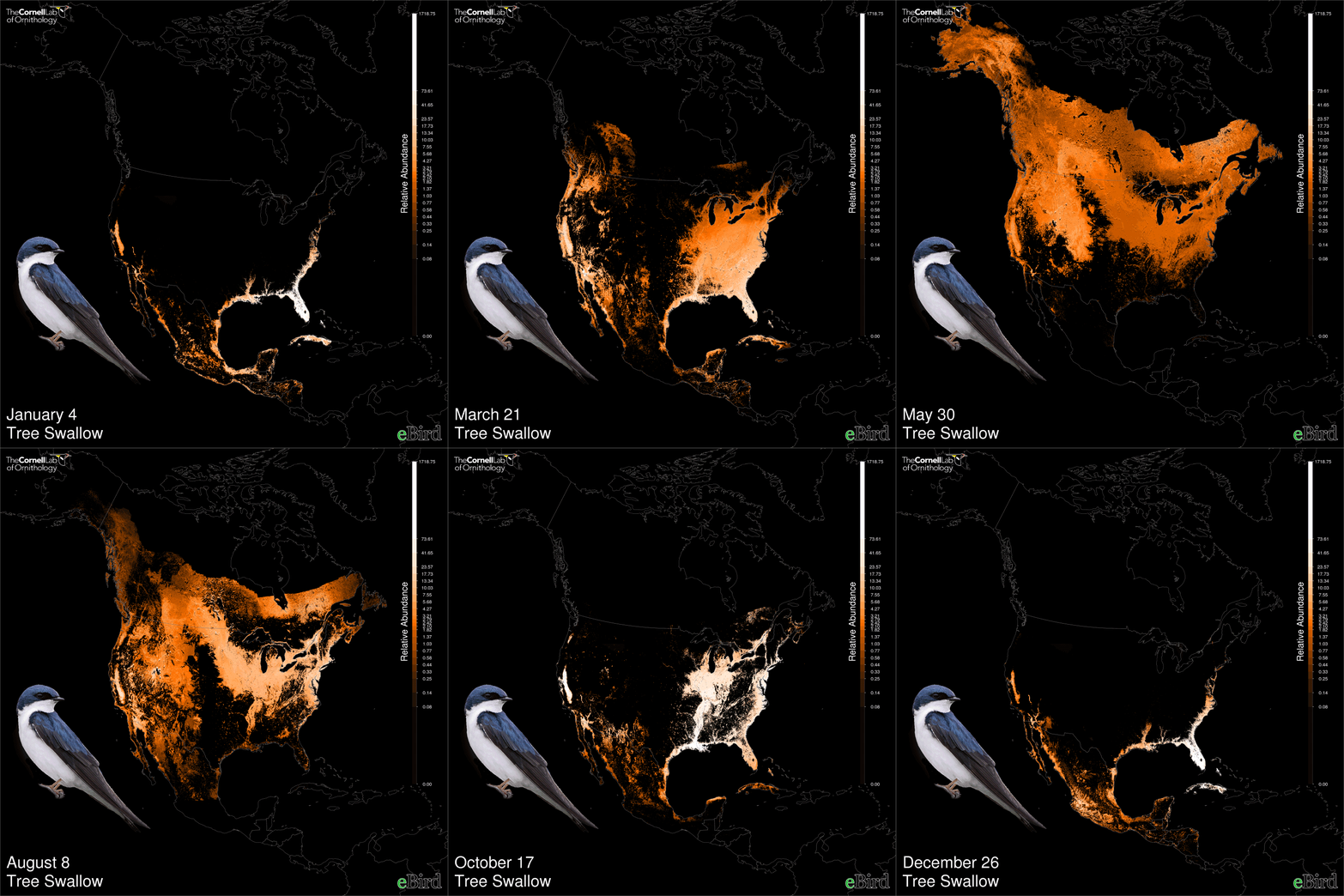
This animation of tree swallows’ annual migration shows how computational sustainability techniques can be used to predict population variations across space and time. Image by Daniel Fink, Cornell Lab. of Ornithology
Combining the data gathered from eBird with the lab’s own observational data and information about species distribution gathered from remote sensing networks, the institute’s models use machine learning to predict where there will be changes in habitat for certain species and the paths along which birds will move during migration.
“There are big gaps where we don’t have observations, but if you relate the patterns of occurrence and absence we see that these birds like a certain kind of habitat and then we can generalize,” Gomes says. “We are really using sophisticated models — algorithms from machine learning — for predicting how the birds are distributed.”
They can then share their predictions with policy-makers and conservationists, who can use it to make decisions about how to best protect bird habitat.
For example, Gomes says, based on information gathered through eBird and processed by the partnership, The Nature Conservancy has set up a “reverse auction” in drought-stricken parts of California, paying rice farmers to retain water in their fields when birds are likely to be migrating and in need of stopover habitat. “This is only possible because we have advanced computational models that give us high-precision information about how birds are distributed,” Gomes says.
Birds are not the only area of research. Much of the institute’s work is related to wildlife conservation — listening to hours of forest recordings to map the location of elephant calls and poachers’ gunshots, for example, or tracking grizzly bears to develop a corridor they can use to move safely through the wilderness.
Upping the PACE
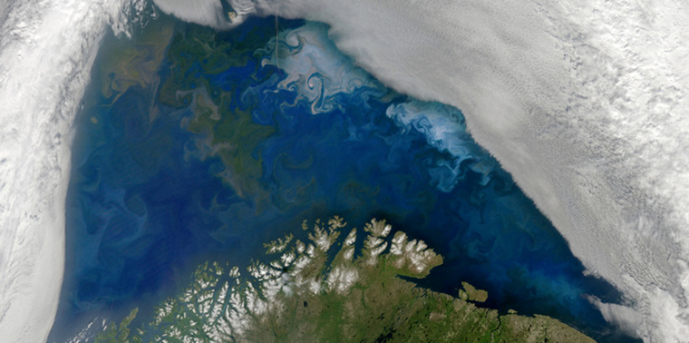
At NASA’s Goddard Space Flight Center, research scientist Cecile Rousseaux is using machine learning to better understand the distribution of phytoplankton (also know as microalgae) in the oceans. These microscopic plants float on the surface of the seas and produce much of the oxygen we breathe. They form the foundation of oceanic food web. They also consume carbon dioxide and, when they die, carry the carbon with them as they sink to the ocean floor.
“If we didn’t have phytoplankton we would see a larger increase in carbon dioxide then we are seeing,” Rousseaux says. Because of this, their overall status is essential information for researchers attempting to understand the effect of changes in atmospheric CO2 on our planet.
Rousseaux is using satellite imagery and computer modeling to predict the current and future conditions of the world’s oceanic phytoplankton. At the moment, the model is only able to estimate the total number of microalgae that live on Earth and how that total is changing over time. But a new satellite mission called PACE (for “Pre-Aerosol Clouds and ocean Ecosystem”), launching in 2022, will open up a whole new data set that looks more closely at the population and be able to identify different species rather than simply looking at the whole, which will substantially change the current model.
“The model uses parameters based on temperature, light and nutrients to tell us the amount of growth. The one thing the simulation does is adjust the total,” she says. But there are a slew of different types of phytoplankton that all interact with the environment in unique ways. Diatoms, for example, are big, sink to the ocean floor very fast and need a lot of nutrients. PACE will make it possible to identify the types of phytoplankton in various parts of the ocean, expanding the model’s ability to help us understand how the microorganisms affect atmospheric CO2. It will also allow us to do things like predict dangerous algal blooms and potentially figure out ways to tap the talents of species that consume carbon in greater amounts to combat climate change.
EarthCube
Speaking of the Earth as a whole, the National Science Foundation is using machine learning to create a 3-D living model of the entire planet. Called EarthCube, the digital representation will combine data sets provided by scientists across a whole slew of disciplines — measurements of the atmosphere and hydrosphere or the geochemistry of the oceans, for example — to mimic conditions on, above and below the surface. Because of the vast amounts of data the cube will encompass, it will be able to model different conditions and predict how the planet’s systems will respond. And with that information, scientists will be able to suggest ways to avoid catastrophic events or simply plan for those that can’t be avoided (such as flooding or rough weather) before they happen.

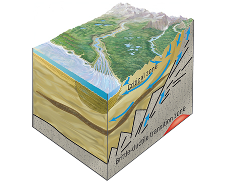
EarthCube combines data sets to create a model that can be used to predict and minimize the damage caused by catastrophic events. Image by Jeanne DiLeo/USGS
As part of the EarthCube project, the U.S. Geological Survey is collaborating on a National Science Framework project to produce the Digital Crust, a framework that will enable more accurate and robust understanding of subsurface processes in the Earth, such as groundwater balance and the health of aquifer systems. “We’ll be able to run scientific calculations that show the level of groundwater over time, and we can pit that against future scenarios,” says Sky Bristol, branch chief of biogeographic characterization at USGS and USGS team lead for the EarthCube Digital Crust project.
Machine learning also comes in to play when two models from different parts of the cube (such as the crust and the atmosphere) have to interact with each other, Bristol says. For example, what does it look like when there’s an increase in groundwater extraction and also an increase in the warming climate at the same time?
The Digital Crust is scheduled to be completed this summer. The Digital Crust and all EarthCube projects are making their data and software open source. So, within a few years, anyone will be able to use machine learning to make predictions about all the possibilities of a future Earth. And that means geoscientists, who work to understand Earth’s various systems and how changes within them will affect humanity, will have a new tool that allows them to share data with each other from around the world — giving their predictions more impact and allowing humans an opportunity to act, rather then react, to our changing world.
These examples are just a small part of the big picture of how computational sustainability can change — and is changing — our ability to make human life on Earth more sustainable. At Cornell alone, other projects using the technology include mapping areas of poverty and the efficacy of poverty mitigation in developed countries, determining the impact of harvesting policies on ocean fisheries, discovering new materials that can be used to capture solar energy, determining the impact of ship strikes on whale populations, and even shedding light on the efficiency and implications of increased gasoline taxes in the U.S. If current trends are any indication, we can expect to hear a lot more in years ahead about how artificial intelligence is helping us make the world a better place to live for the long term. ![]()
Ensia shares solutions-focused stories free of charge through our online magazine and partner media. That means audiences around the world have ready access to stories that can — and do — help them shape a better future. If you value our work, please show your support today.
Yes, I'll support Ensia!

How can my field of education will contribute to protect environment.
Which field is combination of computer science and environment?