
July 11, 2013 — Stretching some 350 kilometers, the 18 main stormwater channels, or nullahs, of New Delhi crisscross the city with more than 15,000 continuous branches. Due to the urbanization of India’s capital city, the nullahs, which were originally a means for excess rainwater to make its way to the Yamuna River and a way to provide water to residents of the region, are now replete with sewage that drains into them from surrounding communities and makes its way, along with stormwater, to the river. Since they are mostly uncovered, this leaves them unhygienic, dirty and stinky.
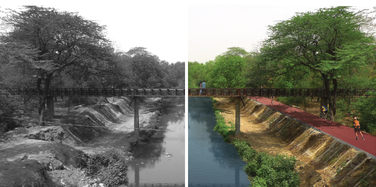
The nullah network has been around since the Tughlaks built it 700 years ago, and residents of India’s capital city have been crying about its lack of upkeep for decades. In response, a group of architects has put forth a plan that would treat the wastewater running through the network at its source where it is dumped into the nullahs, as well as transform areas adjacent to the flowing water into bicycle and walking paths, creating a pedestrian network through the city.
Currently, New Delhi is a nearly unwalkable city, and its roads are dangerous for pedestrians, but the nullahs are so well connected that if they were to be converted as the architects suggest, pedestrians could walk from one end of the city to the other without having to cross a road. And not only would reinventing the nullahs create a safe and connected network and offer an alternate mode of transport, the architects argue, it would allow for last-mile connectivity, an important aspect in allowing all citizens easier access to public transit.
“When Google Earth came along seven or eight years ago, we had the ability to get access to the satellite imaging of Delhi and we traced out all these nullahs. We discovered how intrinsic the network really is.” -Architect Manit Rastogi
The network would have additional environmental benefits as well. Architect Manit Rastogi, managing partner of the Delhi-based firm Morphogenesis, which started this initiative, says the redesign would include adding systems to inexpensively treat wastewater using aerators, reed beds and algae before it enters the nullahs. This, the architects involved say, would improve public health and reduce the need for expensive wastewater treatment plants the government has proposed. Planting trees across the network would also improve water management. Delhi’s (and India’s) groundwater levels are precariously low, which affects the supply of water in the city and the country. Moreover, when it rains in Delhi, the water creates flooding and havoc throughout the city. Trees around the nullahs could slow down the surface runoff and allow stormwater to seep back into the soil to replenish groundwater.
Rastogi thanks Google for the inspiration. “We couldn’t access satellite imagery in India since it was banned due to security reasons,” he explains, “but when Google Earth came along seven or eight years ago, we had the ability to get access to the satellite imaging of Delhi and we traced out all these nullahs. We discovered how intrinsic the network really is.”
Eco-Corridor
A few years before the Commonwealth Games were to be held in Delhi in 2010, the Indian government started allotting funds to sanitize the nullahs. Its goals were shortsighted, however, says Anupam Yog, founder and former managing director of the policy and communications consulting firm Mirabilis Advisory. “[The government] envisioned the exercise more as a beautification project as government agencies tend to do,” Yog says. Yog believes properly dealing with the wastewater in the nullahs before it reaches the Yamuna River was largely ignored in favor of quick fixes and cosmetic updates during the lead-up to the games. Rather than deal with water treatment at the source, architects involved say, the government preferred the idea of installing sewage treatment plants along the river and simply covering some nullahs with concrete, and at the time, the nullah project went nowhere.
But the architects have kept up their efforts, resulting in the nullah project now being scheduled to see the light of day. According to the architects, the Unified Traffic and Transportation Infrastructure (Planning & Engineering) Centre and Delhi Development Authority have adopted it as an eco-corridor project, and a pilot project along the Barapullah nullah has been cleared for implementation.
“Since independence, we’ve thought of our cities as machines that are fundamentally based on either transporting people or facilitating life and work,” Rastogi says. “But Indian cities, in my mind, work more like bazaars — and you have to make the machine and the bazaar, the formal and the informal, come together.”
While there is nothing close to the nullah redesign in scope and challenge, several cities around the world, from Korea to the United States, have been successful with urban regeneration, says Yog. The High Line in New York City, for example, converted a freight railway into a green space that has proven to be a huge tourist attraction — a benefit the architects proposing to redevelop the nullah network say could also likely occur in New Delhi given that many of the city’s archaeological sites and cultural attractions are near the network. While not directly comparable, Yog notes, the High Line speaks to the benefits of creating green opportunities within large cities. Similarly, the Cheonggyecheon Restoration Project in Seoul tore down a major highway, which had been built over a degraded river and sliced through the city’s downtown, to create an urban park along the river. But, according to Rastogi, the redevelopment of New Delhi’s nullahs, if the plan succeeds, would be unique in its size.
Whether all the nullahs will be redeveloped is yet to be determined, and exactly how the treatment will work is something the Barapullah pilot project is meant to clarify. Individual areas and landscape will require distinct treatments. The congestion in North Delhi, for instance, is much greater than that of South Delhi. Architects expect the pilot project to begin to reveal regional idiosyncrasies, and from there, they can test what will or won’t work.
Rastogi sees great potential for the redevelopment to transform India’s second largest city. “Here’s a brilliant opportunity just waiting to be implemented,” he says. “The combination of a completely pedestrian water network with the vehicular network is something no city has seen before.”
![]()
Ensia shares solutions-focused stories free of charge through our online magazine and partner media. That means audiences around the world have ready access to stories that can — and do — help them shape a better future. If you value our work, please show your support today.
Yes, I'll support Ensia!